
Record El Niño Threatens Heavy Rain: How Tuolumne County Residents Can Prepare
International weather forecasters rarely agree, but they do agree that the world is experiencing its most powerful El Niño on record (1). So far, Tuolumne County has been spared the impacts of this super El Niño. That may soon change.
What is El Niño?
El Niño is a natural climate pattern that occurs every two to seven years and is characterized by unusually warm ocean surface temperatures (2)(3). Oceans cover about 71 percent of the Earth’s surface and absorb most of the sun’s warmth. Normally, trade winds push warm surface water west across the tropical Pacific. During El Niño, those winds weaken, and the warm water spills back east toward the Americas (4), releasing some of that stored heat into the atmosphere and shifting weather patterns worldwide (3). This year, that water is exceptionally warm: surface waters in the central and eastern tropical Pacific are more than 3 degrees Celsius (about 6 degrees Fahrenheit) above normal (1).
Human activity adds to the heat. El Niño only redistributes heat already stored on Earth, but burning coal, oil, and natural gas releases gases that trap additional heat in the atmosphere. Climate change doesn’t cause El Niño, but it means each El Niño now starts from a warmer baseline (3).
How is California affected?
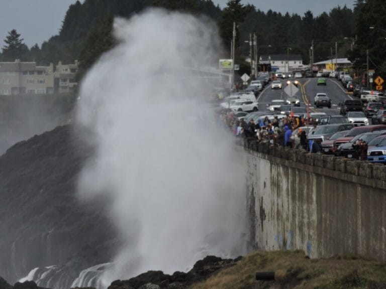
California’s coast is already feeling this El Niño, months before the heaviest storms are expected (1). The warm water spilling east across the Pacific travels as an enormous pulse called a Kelvin wave. Blocked by South America, it splits: one pulse heads south, and the other heads north toward California (4). Along the Southern California coast, water levels are now running one to two feet above predicted tides. The Kelvin wave accounts for 9 to 12 inches of that rise. As the water warms, it expands, adding 6 to 10 inches more; and long-term sea level rise adds 2 to 3 inches. High tides push the water even higher, letting waves reach farther ashore, where they eat away beach sand and undermine coastal structures, causing some to collapse (1).
For Tuolumne County, warm coastal waters mean more energy and moisture for atmospheric rivers — long, narrow bands of water vapor that flow through the sky like rivers. These storms carry Pacific moisture inland, where it falls in intense downpours. Climate scientist Daniel Swain puts the odds of a wetter-than-average California winter at better than 9 in 10, with the heaviest rain expected from December through March (1). Storms like these can wash out roads and bridges, block culverts, trigger landslides, and knock out power.
Why is preparation essential?
If you live in a floodplain or near a creek or other natural watercourse, plan now for possible flooding or extended power outages.
Having your plan in place matters, because local help may be stretched thin. The county’s Office of Emergency Services, which runs emergency alerts and coordinates disaster planning, filled only one of its three analyst positions this spring, and about four employees left or transferred in the previous 18 months (5). With fewer people in that office, your preparation becomes essential.
Take Action
- Clear your home’s drainage system, roadside ditches, and culverts before the storms arrive.
- Sign up for emergency alerts. Tuolumne County’s Everbridge Alert System warns residents of emergencies. Register at tuolumnecounty.ca.gov/1170/Emergency-Alerts, or call the Office of Emergency Services at (209) 533-6395 (6).
- Know where to get sandbags. The county keeps sand available 24 hours a day at sites in Columbia, Tuolumne, Jamestown, and the Big Oak Flat/Groveland area. Bring your own bags. Find addresses at tuolumnecounty.ca.gov/1160/Tuolumne-County-Flood-Information (6).
- Prepare for outages. Storms can bring down trees and power lines, cutting power, phone, and Internet service. Keep flashlights, spare batteries, a charged power bank, and a battery-powered radio on hand, and check PG&E’s outage map at pgealerts.alerts.pge.com/outages/map/.
- Make an evacuation plan in case you must leave your home quickly; the Office of Emergency Services posts preparedness information at tuolumnecounty.ca.gov/1565/Preparedness.
NOTES
- Daniel L. Swain, “El Niño, already near/at record intensity, will further strengthen to historic level and likely bring major California & SW U.S. winter impacts,” Weather West, October 12, 2026.
- “Understanding El Niño & ENSO,” National Oceanic and Atmospheric Administration, June 10, 2026.
- “Three Things to Know: El Niño and Global Temperatures,” Climate Central, October 7, 2026.
- Raymond Zhong, “A Kelvin Wave Is Heading Toward the California Coast, Bringing Trouble,” The New York Times, September 30, 2026.
- Alex MacLean, “Tuolumne County officials explain push to move OES under Sheriff’s Office,” The Union Democrat, April 3, 2026.
- “Tuolumne County Flood Information,” Tuolumne County, California, accessed October 13, 2026.